Randonnée 10180 Caubeyres – Tour télécom - Aquitaine, Lot-et-Garonne (47)
Rando proposée par: Moulin de Campech
Cette page a été affichée 2047 fois.
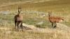
Duration approximately 2 hours 45 mins,13km (Distances in brackets are cumulative) Nature of walk : A few climbs and descents on sandy paths through the woods, great views from the Caubeyres Chateau and the communications tower. Turn right out of gate and then left onto the road to Caubeyres. After 700 metres take the tarmac track on the right. Signposted to Pingareaud and Caillerot. After a few minutes when the tarmac road swings to the right follow the sandy track straight on (1.3km). Follow this flat & straight sandy track (old rail tracks), after about 10 mins at a cross roads turn left. Continue along this sandy track for about 10 mins until you reach a tarmac road (3.2km). Cross straight over onto a stone track passing some wooden cabins and then the “Lavoir” on your right, continue until you reach the tarmac road, turn left up the hill (3.8km). After a couple of minutes you reach a “T junction” turn right, then take the next left on to a stone track. After passing a few properties you will see the ruin of the Chateau of Caubeyres on the hill in front of you, follow the track up to the Chateau. From the plateau there is a lovely view, you can occasionally see the Pyrenees from here (4.7km). The path continues at the far edge of the plateau; continue along this path passing a “palombière” and then after about 10 mins turn left. The track climbs at first then descends past another “Palombière” on your left. In about 5 mins you reach a cross roads, turn left continuing downhill. At the next cross road after another 5 mins turn right, you shortly reach a tarmac road, cross straight over (6.7km). After 250 metres at the next crossroads turn right gently climbing again, after 10mins you reach the main road, cross straight over (WITH CARE), the path now climbs quite steeply, passing yet another “Palombière” on the left. After a short descent and another short climb you reach a cross roads by a cork oak, cross straight over, you may be able to see the communications tower on your left (8.6km). After 5 mins you reach a stone track, turn right then take the sandy track immediately on your left, after a few minutes you emerge from the trees to have a lovely view over the Ourbise valley (9.2km). Continue downhill until you reach a tarmac road, then cross straight over on to the track through the fields passing an abandoned property on your left (10km). This track continues downhill through a small hamlet of properties called Larbes and emerges onto the lane which heads to Villefranche du Queyran, turn left (11km). After about 20mins along the lane you will arrive at the old railway line track, (it is the second track on your right, it begins with a narrow path but soon becomes wider) which will bring you back to the campsite.

Type
Boucle

Distance
13 Km

Altitude maxi
180 M

Altitude mini
60 M

Durée
3h30 min

Difficulté
moyenne


Balisage
Non

Accès
Villefranche du Queyran Lot-et-Garonne (47)

Départ
Camping Moulin de Campech

Dénivelé
250 M

Référence carte
1739E Série bleue IGN
| Photos | Type | Titre |
|---|---|---|
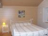 |
Gîte détape | La Vigneraie |
 |
Chambre d'hôtes | La Chambre du Pigeonnier |
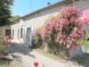 |
Gîte | Gîtes de Beaujardin |
 |
Camping | Camping Moulin de Campech |
| Photos | Nom | Présentation |
|---|---|---|
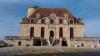 |
Château de Duras - Lot et Garonne - Duras |
Dominant la vallée du Dropt, le Château de Duras est surprenant par sa traversée dans l’histoire de France ! Dès le XII° siècle, le Château, simple castrum, est le témoin des conflits entre l’Angleterre et la France, ce dernier ayant été construit en 1137 par Guillaume Amanieu, vicomte de... |
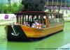 |
Les Croisières du Prince Henry |
Croisières commentée tous les jours de Juin à Septembre à 15 h et 16 h 30 dans la magnifique cité d'Henry IV. En juillet et aout possibilité de déjeuner sur le bâteau tous les jeudis midi Durée de la croisière : 2 heures avec passage d'une écluse dans un cadre enchanteur de verdure... |
 |
Rando-Découverte-Pyrenees |
Je suis accompagnateur en montagne diplômé d'état. J'organise des séjours ou treks dans les Pyrénées pour tous les publics. Passionné par la montagne, je la parcours en toutes saisons. En période hivernale je propose des balades en raquette à neige. Les randonnées sont adaptées au... |

Météo
CLIQUEZ ICI pour enregistrer votre randonnée